
Town · Garfagnana
Vagli Sotto and Careggine
The Village Beneath the Lake
Last updated:
- Region
- Garfagnana
- Province
- Province of Lucca
- GPS
- 44.1167, 10.2833 (Vagli Sotto); 44.1208, 10.3264 (Careggine)
- Best season
- Late spring to early autumn (adventure park and bridge); autumn for color
- Time needed
- Half day; full day with Isola Santa and a walk on the Via Vandelli
- Difficulty
- moderate
- Known for
- Submerged village of Fabbriche di Careggine, Lago di Vagli, suspension footbridge, Isola Santa, Via Vandelli
In the summer of 1994, an estimated one million people came to a small mountain lake in the Garfagnana. They came from across Italy and Europe, and from as far as the United States, Australia, and Japan. They came to see a village that normally doesn’t exist.
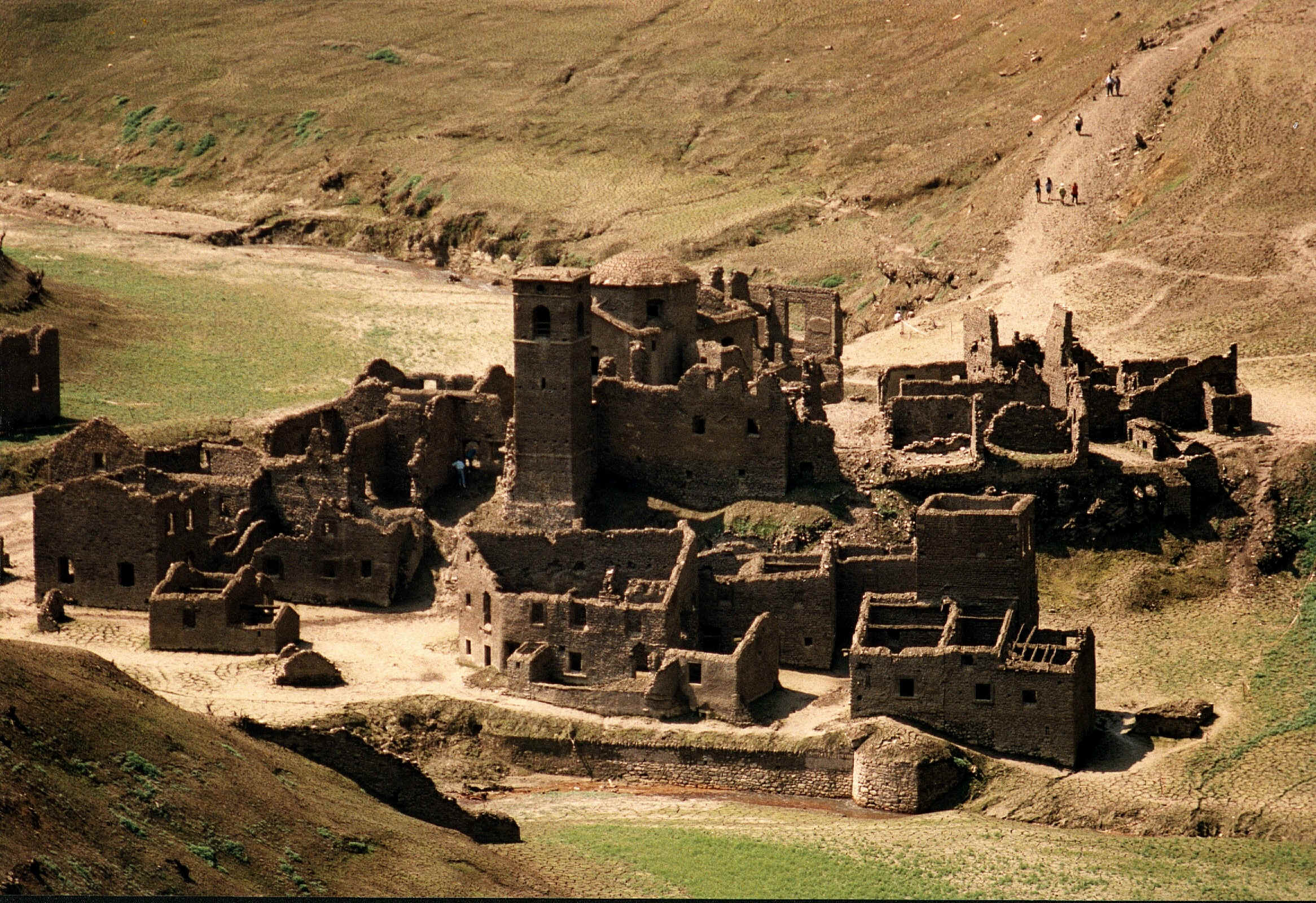
The lake is the Lago di Vagli, a hydroelectric reservoir. The village is Fabbriche di Careggine, which the reservoir swallowed after the dam was built. When engineers drain the lake for maintenance, the stone houses, the church, the cemetery, and a three-arched bridge rise out of the mud. That has happened only four times: in 1958, 1974, 1983, and 1994.
Most of the time, you’ll see only green water. That’s still worth the trip. The story is extraordinary, the setting under the Apuan Alps is dramatic, and the lake now has a suspension bridge, a zipline, and an old Este road running along its shore.
A Place Shaped by Time
A small medieval village
Fabbriche di Careggine was founded in the Middle Ages by ironworkers from the province of Brescia. The fabbriche in its name were their ironworks. By the time it was flooded, it was a small village of about 30 stone houses and 146 inhabitants, with a mill, a cemetery, and a church, San Teodoro, dated to 1590.
The dam
In the 1940s, the SELT-Valdarno company (today part of Enel) built a 92 m dam across the Edron stream to create a reservoir for hydroelectric power. Sources differ on the exact dates of construction and flooding. The reservoir holds more than 30 million cubic meters and is the largest hydroelectric basin in Tuscany. The villagers had to leave, and the water closed over their homes.
Four resurfacings
Each time the reservoir has been emptied, the village has reappeared: roofless houses, the ruined bell tower, the cemetery, the bridge. The 1994 draining turned into a pilgrimage. For the families who had left, it was a chance to walk their old streets again, almost 50 years later.
Waiting for the next one
Since 1994, a new draining has been announced and postponed several times. Plans for spring 2023 and then spring 2024 were put off, with drought among the reasons. In March 2026, Vagli’s mayor, Mario Puglia, pointed to summer 2027, 33 years after the last one. He tied it to roads, parking, and visitor facilities being ready first. Enel, which runs the dam, no longer needs to empty the reservoir for maintenance, because it now inspects it with underwater technology.
Treat 2027 as a plan, not a confirmed date. If it happens, it will be a major event. Book accommodation early and expect heavy crowds.
What to See and Do
The lake itself
Even full, the Lago di Vagli is striking. It lies under the pale Apuan peaks, long and narrow, with steep wooded banks. Walk along the shore road from Vagli Sotto and try to picture a village under your feet.
The suspension footbridge
At VagliPark, a pedestrian rope suspension bridge, often called the “Tibetan bridge,” spans the lake. It opened in 2016 and hangs about 100 m above the water, with a transparent glass section in the middle of the walkway. Check current visitor information before you go.
If you’re uneasy with heights, the glass section will test you. If you’re fine, it’s the best view of the lake.
Volo dell’Angelo and the adventure park
The Volo dell’Angelo (Angel’s Flight) is a zipline over the lake, about 1.5 km of steel cable. The ride takes around two minutes, at speeds of more than 130 km/h. It first opened in 2017 and restarted in 2026 after a period of closure. VagliPark also runs a Parco Avventura (adventure park). Prices and seasons change, so check before you go.
Isola Santa
Upstream, the hamlet of Isola Santa sits on its own small lake, the Lago di Isola Santa. It’s a small, restored stone hamlet by the water. Administratively it belongs to Careggine. Come in the morning or late afternoon when the light is low across the water.
The Via Vandelli
The Via Vandelli was an Este road, designed by the court mathematician and cartographer Domenico Vandelli. Work began in 1738 and was completed in 1751. It linked Modena to Massa over the Apennines and the Apuan Alps. It runs past the Lago di Vagli, above the drowned village, and climbs to the Passo della Tambura at about 1,620 m.
In its day it was steep, snowbound in winter, and plagued by brigands, “little more than a mule track.” Today it’s a restored multi-day hiking route. You can walk a section from the lake for a taste. The full climb to the Tambura is a serious mountain hike.
Eating Like a Local
La Ceragetta
In the hamlet of Capanne di Careggine, Ristorante La Ceragetta looks out over the Lago di Isola Santa and the Panie peaks. It is family-run, with homemade pasta, seasonal menus, and a zero-kilometer approach to ingredients. It has taken part in the Apuan Alps park’s zero-kilometer menu program. It is one of the best reasons to drive up here. Check current opening days before you go.
What to order
This is chestnut and farro country. Look for zuppa di farro, polenta di neccio (sweet chestnut-flour polenta), and in winter biroldo, the valley’s spiced head-meat sausage.
Getting There and Getting Around
By car
From Castelnuovo di Garfagnana, follow the SR 445 and turn off at Poggio for Careggine and Vagli. Roads are narrow and winding, so allow extra time. Isola Santa lies on the road toward the Apuan side and Passo del Vestito.
By train
The nearest station is Poggio–Careggine–Vagli on the Lucca–Aulla line. The lake is still a long climb uphill. Check local bus routes and times before you go, or arrange a taxi.
Timing
The adventure park and bridge run seasonally. In winter the lake is quiet and beautiful, but most attractions are closed. If a draining is ever confirmed, expect road closures and park-and-ride arrangements.
Nearby
- Castelnuovo di Garfagnana: the valley’s capital and the most practical base.
- Camporgiano and Piazza al Serchio: the upper valley’s Este fortress and farro fields.
- Minucciano and Gorfigliano: marble quarries under Monte Pisanino, the highest Apuan peak (1,945 m).
- Passo del Vestito: the Apuan crossing toward Massa and the coast.
Information is provided in good faith and may change. Always confirm opening hours, prices, and event dates with the official source before you travel.