
Town · Maremma
Orbetello
The Capital of Spanish Tuscany, Built on a Lagoon
Last updated:
- Region
- Maremma
- Province
- Province of Grosseto
- GPS
- 42.4428, 11.2244
- Best season
- spring and autumn
- Time needed
- full day (two with Ansedonia and Talamone)
- Difficulty
- easy — the old town is flat and sits at sea level
- Known for
- Stato dei Presidi, lagoon fishing, bottarga, Roman Cosa, Feniglia pinewood
Orbetello sits on a thin finger of land in the middle of a lagoon. A causeway, the Diga Leopoldina, runs from the town to Monte Argentario, the rocky former island to the west. On a map it looks improbable, and in person it still does.
The bigger surprise is political. For about 250 years, this town was not part of Tuscany at all. It was the capital of a small Spanish military state on the Tuscan coast, run from Naples. One of its gates is named after a Spanish viceroy of Naples, and its best museum sits inside a Spanish powder store.
Most visitors drive straight through to the Argentario beaches. Give Orbetello a day instead. You get Etruscan walls, a working fishing lagoon with its own Slow Food Presidium, a Roman colony on the next hill, and some of the most honest seafood on this coast.
A Place Shaped by Time
Etruscan stones under Spanish bastions
The oldest thing you can touch in Orbetello is a stretch of polygonal wall along Via Mura di Levante. Italian sources date it “almost certainly” to the 5th century BC, which makes it Etruscan. Later builders simply put their walls on top.
The Stato dei Presidi: Spain’s corner of Tuscany
After the fall of Siena, Philip II of Spain kept this coast for himself. At the Treaty of London in 1557 he created the Stato dei Presidi (the State of the Garrisons). It was administered through the Spanish viceroys of Naples, and Orbetello was its capital.
The state held Orbetello with Ansedonia and Talamone, plus Porto Ercole and Porto Santo Stefano on the Argentario. Porto Longone on Elba (today Porto Azzurro) was added in 1603 or 1604.
Spain held it until 1707, Austria from 1708, and the Bourbons of Naples from 1733. In 1801 it passed to France for the short-lived Kingdom of Etruria. Only at the Congress of Vienna in 1815 did it join the Grand Duchy of Tuscany. Orbetello’s gates, in other words, belong to a Spanish garrison town that became Tuscan less than a lifetime before Italy existed.
Seaplanes and propaganda
From 1928 to 1933 Orbetello’s seaplane base was the training and operations center for Italo Balbo’s mass formation flights. Balbo was one of the leading figures of the Fascist regime, and these flights were political theater as much as aviation. They included a 1930–31 crossing from Orbetello to Rio de Janeiro. On 1 July 1933, 25 SIAI-Marchetti S.55X flying boats left the lagoon for Chicago and New York. Two men died on that tour, and 24 aircraft came back.
The story ended in ruins. On 12–13 June 1944, German demolition teams razed the hangars and almost all the military structures. Naming the area after Balbo later drew a public protest from the Istituto Nazionale Ferruccio Parri. The story belongs in a history lesson about fascist propaganda, not a nostalgia trip.
What to See and Do
The Spanish walls and gates
Walk the ring of the old town first. Five Spanish bastions run from Burgos in the north to Guzman in the south, and three gates survive. Porta del Soccorso dates from 1620. Porta a Terra (1692) carries five marble coats of arms and a statue of St Blaise. Porta Nuova, also called Porta Medina after a viceroy of Naples, dates from 1697. The moat is gone, but the plan is easy to read.
The Polveriera Guzman archaeological museum
This is the museum to see in Orbetello, and the building tells the Spanish story too. It was built in 1692 to a design by the Flemish architect Ferdinand De Grunembergh, first as a general warehouse and later as a gunpowder store. It takes its name from the nearby bastion, dedicated to the Spanish viceroy Enrique de Guzmán.
Inside is the Museo Archeologico. It holds Etruscan grave goods, inscribed bronze mirrors, and elements of the temple at Talamone, including a helmet with an Etruscan inscription. Note that the museum is not wheelchair accessible. Check current hours on the Musei di Maremma page before you go.
The Duomo
The co-cathedral of Santa Maria Assunta was rebuilt between 1370 and 1376. Look at the late-Gothic façade, carved portal, and rose window. Inside, the front of the high altar is an early medieval marble slab with 24 relief panels. It was found only in 1964.
The lagoon and its fishermen
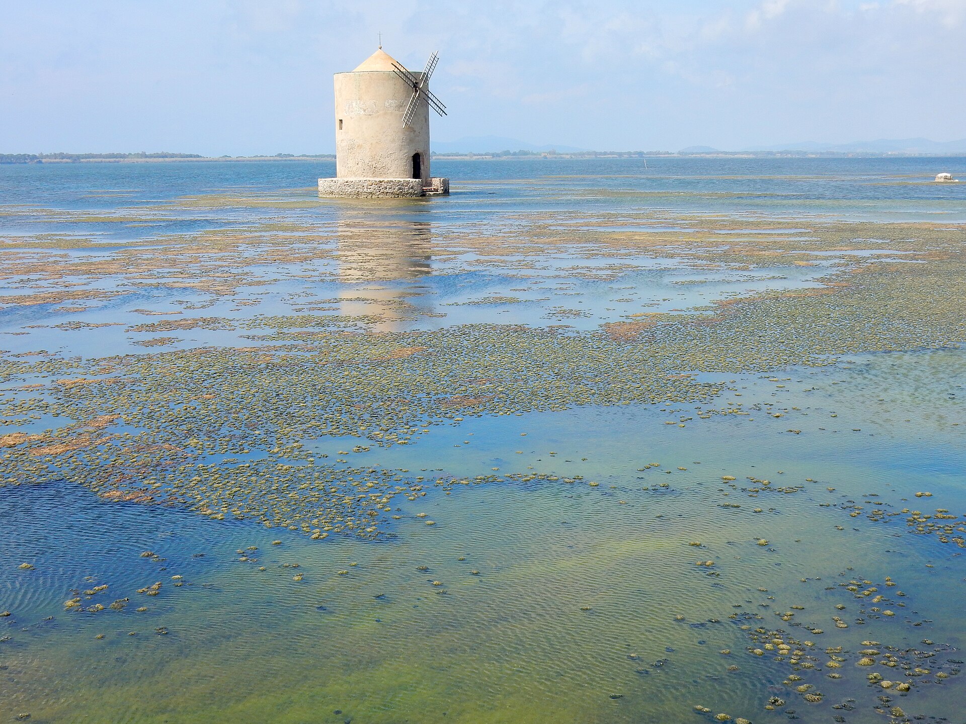
The lagoon covers about 27 km² and averages about 1 m deep; nowhere does it pass 2 m. Two sand spits enclose it, the Tombolo della Giannella and the Tombolo di Feniglia, each about 6 km long. The Diga Leopoldina splits it in two.
This shallow water is a working fishery. Fishermen still use the lavoriero (a tidal barrier trap), the tramaglio (a three-layer net), and traps for eels, crabs, and shrimp. The cooperative was founded in 1946 by thirteen fishermen, and we tell their story in our profile of the Pescatori di Orbetello.
Shallow water heats fast. In hot summers, decaying algae strip the water of oxygen, and fish die in huge numbers. In 2015 about 200,000 kg of fish were lost. In July 2024 more than 24,000 kg of dead fish, mostly eels, bream, and bass, had been removed by the time Il Post reported it. The die-off also reached the beaches at Ansedonia, Feniglia, and the Tagliata. Eat lagoon fish here and you support people working on the front line of a warming sea.
The WWF oasis (by booking)
The WWF Oasi Laguna di Orbetello protects 870 ha of the western lagoon, within a larger regional reserve. You may see flamingos, herons, cranes, ospreys, and marsh harriers. The entrance is on the Aurelia southbound carriageway and is reachable only by car. In the warm months visits are guided only and must be booked the day before, and the oasis closes during weather alerts. Check the WWF oasis page for the current season’s rules.
Feniglia: a pinewood with deer
The Riserva Duna Feniglia covers 474 ha of the southern sand spit, between lagoon and sea. It is open only on foot and by bike. The pinewood was planted from 1912. About 200 fallow deer live here, descended from animals introduced around 1954, and wolves have been present since 2017. There is an accessible nature trail.
Ansedonia, Cosa, and the Tagliata
Ansedonia, part of Orbetello’s comune, sits on a promontory south-east of the lagoon. Above it is one of Tuscany’s best Roman sites.
Cosa: a Roman colony on a hill
Rome founded Cosa in 273 BC, to hold land it had just taken from the Etruscan city of Vulci. The American Academy in Rome excavated it, “particularly under Frank Brown’s direction”, and published the results from 1951 to 2003.
You enter through the Porta Fiorentina, in massive polygonal walls. Inside are the Arx with the main temples, two excavated houses (the Casa dello Scheletro and the Casa di Diana), a bath complex, the Forum, and the Via Sacra. Wear proper shoes; this is a hilltop site, not a paved museum. The site museum has been closed for reinstallation since January 2026, while the park stays open; check the Parchi Archeologici della Maremma page for updates.
The “Etruscan” cut that probably isn’t
Below the hill, a channel cut through the rock carries the Canale della Tagliata, the outlet of Lake Burano, to the sea. Everyone calls it the Tagliata Etrusca (the Etruscan Cut). The Treccani encyclopedia is blunter: “long believed Etruscan, it is more probably a work of Roman Republican engineering.” It sits right below a Roman colony, which makes the Roman reading easy to believe.
Next to it, the Spacco della Regina (the Queen’s Crack) is a natural fissure about 110 m long. It was reworked even earlier than the Tagliata, for a purpose nobody is sure of.
Puccini’s tower, briefly
Giacomo Puccini bought the 16th-century Torre della Tagliata, beside the cut, around 1919. On 27 April 1919 he wrote: “Ho una torre meravigliosa in Maremma… È sul mare a 10 metri” (“I have a marvelous tower in the Maremma… It is on the sea, 10 meters away”). He had sold it by 30 January 1921.
English sites inflate this short ownership. There is no evidence he wrote Turandot here. An eyewitness saw him on the beach with pencil and manuscript paper on his knees, and the source cautiously links this to Il Tabarro. Puccini befriended the Guardia di Finanza men stationed next door, and in 1925 they put up a marble plaque dedicating the tower to him. We could not confirm whether the tower can be visited, so enjoy it from the beach.
Talamone
Talamone, a small frazione of Orbetello on the coast to the north, deserves a half day of its own. Garibaldi’s Thousand stopped here from 7 to 9 May 1860 because they had no ammunition. Orbetello helped arm them: after Garibaldi’s men persuaded its commander, Colonel Giorgini, the town’s National Guard handed over about 300 rifles. The stay was not heroic. When Garibaldi asked for volunteers for a diversion into the Papal States, only 64 men came forward, “with little enthusiasm”. Shore leave ended in fights with the locals, and an angry Garibaldi ordered everyone back aboard.
Much earlier, in 225 BC, Rome destroyed a Celtic invasion at nearby Campo Regio. Talamone is also the start of the Parco della Maremma’s T trails; check routes on the park’s website.
Eating Like a Local
What comes out of the lagoon
Orbetello’s food is lagoon food, and its best-known product is bottarga, the cured roe sacs of female grey mullet. Look also for anguilla sfumata (smoked eel) and two preserving methods that Slow Food credits to the Spanish period. Sfumatura means fish dressed with a pepper-based sauce. Scavecciatura is a hot dressing of vinegar, rosemary, garlic, and pepper. Bottarga and these two methods are part of the Slow Food Presidium for traditional lagoon fishing.
Where to try it
The fishermen’s cooperative runs its own Centro Degustazione, a tasting center and restaurant. On the Giannella road, L’Oste Dispensa won Slow Food’s Chiocciola (snail) award in the Osterie d’Italia 2026 guide, one of only a handful in the province of Grosseto.
What to drink
Two small wine zones include Orbetello: Ansonica Costa dell’Argentario DOC, a white from the coast and islands, and Capalbio DOC. A cold Ansonica with bottarga is the local answer to lunch.
Getting There and Getting Around
By train and bus
Orbetello is on the Tirrenica railway between Pisa, Grosseto, and Rome. Its station, Orbetello–Monte Argentario, is in the Orbetello Scalo district on the eastern side of town, not in the old center. Autolinee Toscane’s line 11P links Orbetello with Albinia and Pitigliano; check timetables before relying on it. For the WWF oasis, Cosa, and most beaches, you will want a car.
By car
The SS1 Aurelia is the main road. As of April 2026, a stretch of about 13 km around Capalbio, south of Orbetello, was still two-lane, with what local reporting called an alarming accident rate (Il Giunco), so drive it with care. For ZTL and parking rules, check the Comune di Orbetello before driving into the old town. A tourist tax applies; your accommodation will tell you the rate.
When to come
Spring and autumn are the best seasons, with milder heat and fewer crowds. In winter, the Carnevaletto da Tre Soldi fills the streets with allegorical floats.
Nearby
- Porto Ercole — Spanish forts on the Argentario, and the honest version of the Caravaggio story.
- Capalbio — a walled hill village south along the Aurelia, with Niki de Saint Phalle’s Tarot Garden nearby.
- Magliano in Toscana — a walled hill town, where a famous Etruscan lead disc was found.
- Pitigliano — the tufa town with a Jewish ghetto, reachable inland by bus line 11P.
- Grosseto — the provincial capital inside its Medici walls, north along the Aurelia.
Information is provided in good faith and may change. Always confirm opening hours, prices, and event dates with the official source before you travel.