
Town · Maremma
Sorano
A Fortress, a Cave Village and a Lost County
Last updated:
- Region
- Maremma
- Province
- Province of Grosseto
- GPS
- 42.6819, 11.7147
- Best season
- spring and autumn
- Time needed
- full day (two with Vitozza and the frazioni)
- Difficulty
- moderate (steep lanes, ramps and unpaved paths)
- Known for
- Fortezza Orsini, Masso Leopoldino, Vitozza cave settlement, County of the Ottieri, thermal water
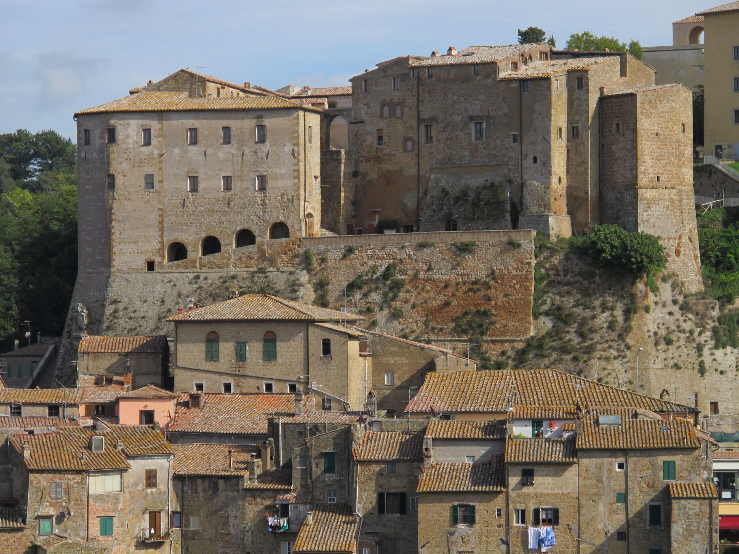
Sorano hangs over a river gorge, a stack of tufa houses under a fortress. Most visitors stop at the viewpoint, take the picture and drive on to Pitigliano. That is a mistake. Sorano has a better castle museum, a stranger history and, a walk away, a cave village that the local paper Il Giunco calls one of the largest rock-cut settlements in Italy.
The comune of Sorano is also far bigger than its old town. It takes in about ten frazioni (outlying villages), including Sovana, San Quirico, Castell’Ottieri and Montorio. Two of them, with their neighbors, once formed a tiny independent state that survived until 1616. Almost nothing about it exists in English.
This profile covers Sorano itself, the cave village of Vitozza and the old County of the Ottieri. Sovana, also part of the comune, has its own profile.
A Place Shaped by Time
Aldobrandeschi, Orsini and Siena
Like its neighbors, Sorano belonged first to the Aldobrandeschi counts. It passed to the Orsini after Anastasia Aldobrandeschi married Romano Orsini in 1293. Siena contested the town: it besieged Sorano several times in the 15th century and occupied it in 1417.
The Orsini’s lasting mark is their fortress, which was completed in 1552 for Count Niccolò IV Orsini, with Anton Maria Lari given as its architect. According to Italian Wikipedia, the Medici also set up a ghetto in Sorano in 1619. The former synagogue survives as an exhibition space, and you can still see marks left by the hinges of the ghetto gate.
The landslides of 1801–1804
Sorano’s older stronghold, the Rocca Vecchia, stood on a tufa spur above the town. Between 1801 and 1804 a series of landslides struck it. The collapses were blamed on digging beneath the tufa. According to Italian Wikipedia, they killed several dozen people and destroyed the adjacent church of Santa Caterina, first documented in 1565.
Repairs took the next two decades. The site took the name Masso Leopoldino in memory of the grand duke who paid for them. The spur needed stabilizing again in the 1960s and 1970s. Walk up and remember that the town’s building stone is also its greatest risk.
The County of the Ottieri: a micro-state until 1616
The Ottieri family ruled a pocket-sized county. It included Castell’Ottieri, its capital, plus Montorio, San Giovanni delle Contee and the castle of Sopano. Its founding story is a legend. A judicial decision of 1665 says Castell’Ottieri was founded by a man-at-arms who came down into Italy from the “Provincia d’Austria”.
Orvieto took control in the 13th century; the Ottieri then seized it and made it their seat. Apart from a temporary submission to Siena in the 15th century, they held on. The end came by sale, not conquest. On 16 April 1616, according to Italian Wikipedia, Sinolfo Ottieri, son of Flaminio, ceded the county to Grand Duke Cosimo II of Tuscany for 107,000 piastre and the grand-ducal fief of Rigomagno.
Vitozza: a town of caves
Vitozza grew in the late 11th century around an Aldobrandeschi castle. It was built inside a rock settlement already used in Etruscan and Roman times. Orvieto and the Baschi family held it in the early 13th century, then Siena from the late 13th to the mid-15th century, then the Orsini.
People kept living in its caves for centuries. A Lorraine census of 1783 still recorded families living in the caves, and panels at some cave entrances now show their names. By the end of the 18th century the site was empty, for reasons that remain unclear. Residents drifted to nearby villages, among them San Quirico, which grew up during the 1700s as Vitozza declined.
What to See and Do
Fortezza Orsini and its museum
The fortress has a central keep and two bastions, San Marco and San Pietro. Inside is the Museo del Medioevo e del Rinascimento (Museum of the Middle Ages and the Renaissance). Its main collection is medieval and Renaissance pottery, recovered from the town’s butti, medieval rubbish pits. Guided tours of the underground passages start from the ticket office. Bring a jacket.
The octagonal room: a correction
The best room is in the octagonal tower. It is painted with grotesque-style decoration, plus a painted musical score. The official English page of the Musei di Maremma calls these “fifth-century frescoes”. That is impossible in a fortress completed in 1552. The error is almost certainly a mistranslation of the Italian Cinquecento, meaning the 1500s. Italian Wikipedia’s page on the Sorano museum dates the fresco to 1540–1560.
The score is the real prize. According to the same page, it is the madrigal Io mi son giovinetta (“I am a young girl”), the song Neifile sings at the end of the ninth day of Boccaccio’s Decameron. The Bolognese composer Domenico Ferrabosco set it to music in 1542. A 2006 article in the Italian philology journal Critica del testo studied the painted text and music. The museum’s English page calls the room Niccolò IV’s private room for entertaining; take the more colorful versions as local lore.
For current opening times and tour slots, contact the Città del Tufo park (tel. 0564 633767 / 633099 / 614074, info@leviecave.it) or see the Musei di Maremma page.
Masso Leopoldino and the old town
A ramp from Piazza del Poggio leads up to the Masso Leopoldino. The medieval clock tower there once held the municipal bell. The rock served as a garrison, lookout and refuge during sieges until the new fortress took over that role.
Below, the Collegiata di San Niccolò has Romanesque origins. It became a collegiate church in 1509 and was heavily rebuilt in 1779. Then look for the former ghetto and the hinge marks of its gate. Since August 2026 a 40-minute audio guide in English, Italian, German, French and Spanish runs through QR codes around town (Il Giunco).
Vitozza on foot
Vitozza has more than 200 caves. Some are rectangular homes on several levels. Others are colombari, niches for breeding pigeons, probably of Roman date. You will also find the ruins of two fortresses, a parish church and the medieval church known as La Chiesaccia. The site is about 2 km from San Quirico and reachable only on foot. Go in dry weather and wear boots.
Vitozza is part of the Parco Archeologico Città del Tufo, which also covers the rock-cut settlement of San Rocco, with its 16th-century church, near Sorano. The park publishes no hours or prices online, so phone or email before you go (cittadeltufo.com).
Castell’Ottieri and Montorio
Castell’Ottieri (472 m) had 163 residents in 2011. The Ottieri built its Rocca in the Renaissance around an older Aldobrandeschi fortress, with a round tower and tufa masonry. The church of San Bartolomeo was built at the end of the 16th century by Sinolfo Ottieri, and holds a Madonna painting of 1590.
Montorio (483 m) keeps a 12th-century Aldobrandeschi castle, later turned into a fortified farmhouse, and 12th-century walls. Its church of Santa Maria is 19th-century Gothic Revival. Together, the two villages make a quiet half-day drive with a story few visitors know.
Terme di Sorano
If you want thermal water in a resort setting, Terme di Sorano is a resort in a 7-hectare park around an old parish church. Its main pool is 37.4°C, open year-round, and includes the 15th-century “Bagno dei Frati” (Friars’ Bath). Day-spa entry is bookable, and a sports pool opens in the warm months. Check the site for prices and booking.
Eating Like a Local
Sorano’s own sweet is the cialdino dei tufi. Here, as in Pitigliano, the thin cheese-topped fritter called ciaffagnone in Manciano goes by the name migliaccio. Look out, too, for Pitigliano’s sfratto, the honey-and-walnut pastry whose story involves Sorano’s Jews as well; our Pitigliano profile tells it.
For a meal in the old town, Cantina L’Ottava Rima on Via del Borgo is a small osteria in a tufa grotto. A 2023 Italian regional guide describes it as serving traditional and seafood dishes. Check its website for hours.
The local wines are Sovana DOC (created in 1999), which covers all of Sorano and Pitigliano and part of Manciano and includes a sweet Aleatico Passito, and Bianco di Pitigliano DOC.
Getting There and Getting Around
By car
A car is essential. Italian Wikipedia states plainly that the comune of Sorano has no railway station. Sorano and Sovana have paid car parks; current rates are not published in any source we could check, so bring coins and a card. No ZTL rules could be confirmed, so follow the signs and park outside the old town.
Sovana is about 9 km from Sorano. San Quirico, Castell’Ottieri and Montorio are reached by country roads.
By bus and on foot
The Autolinee Toscane lines that serve the area run from Pitigliano (at-bus.it); check whether any service reaches Sorano on your travel day. In town, expect steep lanes and ramps. The Vitozza path is unpaved.
A seasonal note
In recent seasons Tuscany’s driven wild-boar hunts (braccata) have run from 1 October to 31 January, on Wednesdays, Saturdays, Sundays and holidays. On those days, wear bright clothing and stay on marked paths when walking to Vitozza or in the countryside. A tourist tax may apply to overnight stays; check with your accommodation.
Nearby
- Sovana – the Aldobrandeschi capital, with its cathedral, Etruscan tombs and the Cavone sunken road.
- Pitigliano – the tufa town of “Little Jerusalem”, with its synagogue and Orsini palace.
- Saturnia – the Maremma’s best-known hot springs, free to bathe in.
- Montemerano – a walled hill village and one of the Maremma’s serious food stops.
Information is provided in good faith and may change. Always confirm opening hours, prices, and event dates with the official source before you travel.