Region guide · Province of Grosseto
Colline Metallifere
The Hills That Powered Five Thousand Years
Last updated:
- Province
- Province of Grosseto
- Main town
- Massa Marittima
- Best season
- May–June (wildflowers, Balestro crossbow tournament, uncrowded beaches); September (warm sea, harvest, hiking weather)
- Known for
- UNESCO Global Geopark, 5,000 years of continuous mining, geothermal energy (world's first power plant), Massa Marittima cathedral, Cala Violina singing-sand beach, medieval mining code, wild boar cuisine
- Getting there
- Follonica station on the Rome–Pisa Tirrenica line; A12/E80 Aurelia motorway exit Follonica Est; Florence ~2–2.5 hours by car
The name Colline Metallifere means “metal-bearing hills.” Yet this is not a story about geology alone.
These hills produced a medieval republic that rivaled Siena. They hold a cathedral with works by Duccio and Ambrogio Lorenzetti. They gave Europe one of its earliest comprehensive mining codes and the world its first geothermal power plant. They also saw one of the worst Nazi massacres in wartime Italy. And they end at some of the finest free beaches on the Tuscan coast.
Nowhere else in Italy offers quite this range. In one trip, you can walk through active geothermal fumaroles and swim in a cove where the sand sings. You can watch a medieval crossbow tournament, then stand before the memorials of industrial tragedy.
Yet almost none of this is known to English-speaking travelers. Take Massa Marittima, the capital. It packs the artistic density of a Sienese satellite into a compact hilltop town. Even so, most English-language guidebooks give it a paragraph or skip it entirely.
Monterotondo Marittimo has a free geothermal park that may be Tuscany’s most visually spectacular attraction. Hardly anyone outside Italy has heard of it. Then there is Cala Violina, a beach whose quartz sand makes a violin-like sound when you walk on it. It has a mandatory reservation system that English-language travel content has barely covered.
This guide covers the full picture: the seven core municipalities, the mining and geothermal story, the food, and the festivals. It also covers the practical logistics. Together, they make the Colline Metallifere one of Tuscany’s most rewarding detours.
The shape of the land
Where the hills begin and end
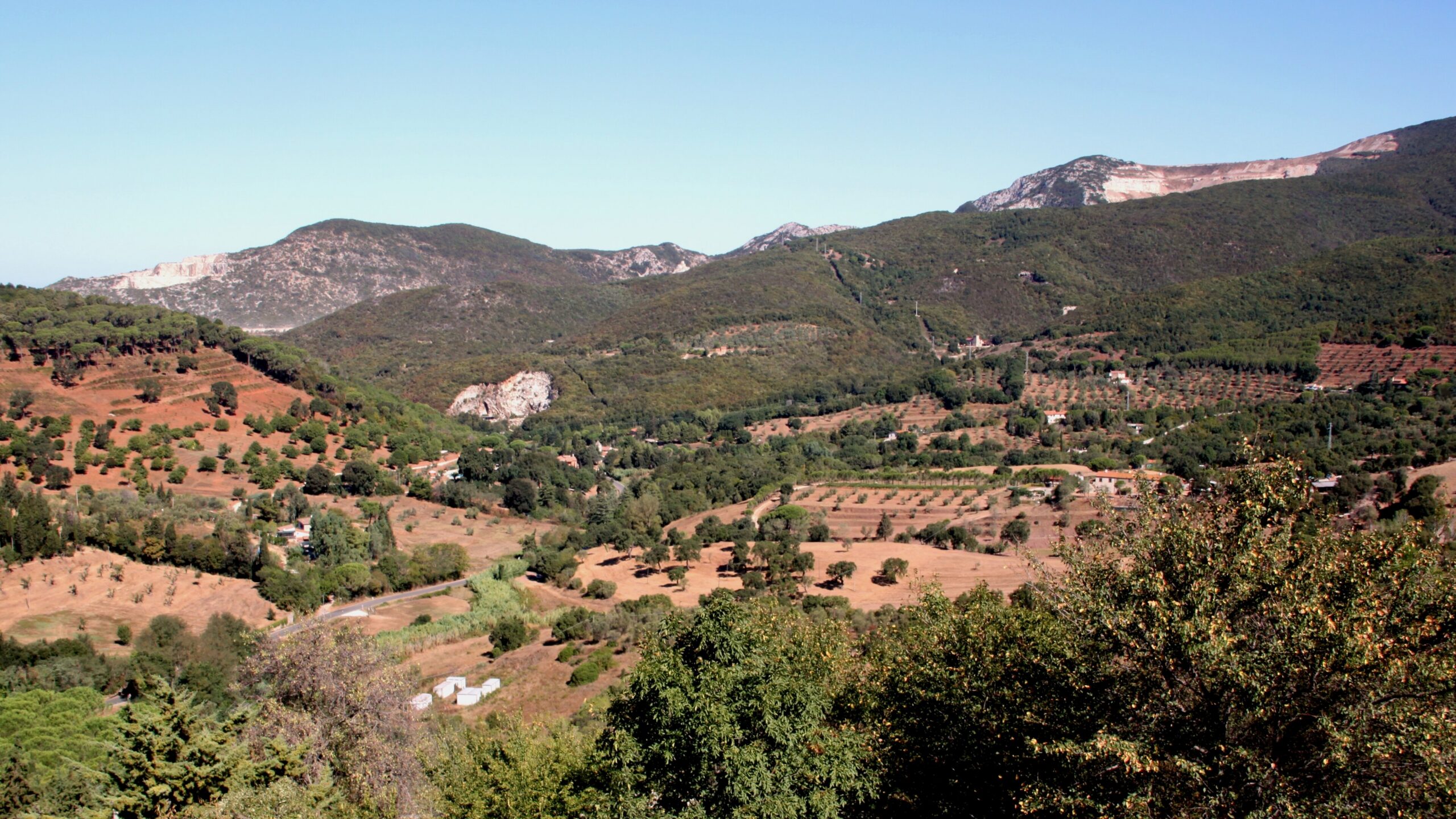
The Colline Metallifere occupy the southwestern part of the Tuscan Anti-Apennine, a chain of hills with four natural borders. The Cecina River lies to the northwest, the Merse to the east, and the Ombrone to the south. To the west is the Tyrrhenian Sea, specifically the Gulf of Follonica.
The range peaks at the Cornate di Gerfalco (1,059 meters), a dramatic limestone massif with seven peaks near the tiny village of Gerfalco. The Poggio di Montieri also tops 1,050 meters. At the other end, Follonica sits at sea level. Within 30 kilometers, the landscape changes completely. Chestnut and beech forests cover the crests, and dense Mediterranean scrub (macchia) fills the middle slopes. Along the coast, quartz-sand coves and pine-backed beaches take over.
Seven municipalities and a Geopark
Seven core municipalities make up the area:
- Massa Marittima (380 meters): the cultural capital
- Montieri (705 meters): the mountain of copper
- Monterotondo Marittimo (539 meters): the geothermal heartland
- Roccastrada (475 meters): villages built on boulders
- Gavorrano (273 meters): Europe’s largest pyrite mine
- Scarlino (229 meters): fortress and singing beaches
- Follonica (sea level): the cast-iron gateway
In 2022, the UNESCO Geopark grew to include three more municipalities. Castelnuovo di Val di Cecina and Pomarance (home to Larderello) are in Pisa province, and Radicondoli is in Siena province. As a result, the geothermal story now crosses the provincial border.
Between the Maremma and Siena
The neighbors help place the area on the map. The Maremma plain stretches south toward Grosseto. The Val di Cecina lies to the northwest, toward Volterra, and the Val di Merse borders the east. In effect, the Colline Metallifere form the northern wall of the Grosseto Maremma. They mark the shift from flat coastal lowlands to the rolling interior hills around Siena.
The approach tells the story. Coming from Florence or Siena in the north, you drive through wilder and emptier country. From Grosseto or Rome in the south, the hills rise suddenly from the Maremma plain, like a geological statement.
Fifty centuries underground
Mining is the thread that connects everything here, from the Etruscan smelters to the geothermal power plants. It is one of the longest continuous industrial stories in Europe.
From the Etruscans to a medieval republic
Mining here dates back at least to the Copper Age, around 3000 BC. Systematic Etruscan exploitation began by the eighth century BC. The key archaeological site is Lago dell’Accesa, a karst lake roughly 10 kilometers south of Massa Marittima. Here, excavations revealed an Etruscan settlement from the seventh to sixth century BC. It was organized into five quarters, and one of them contained metalworking furnaces.
The Romans continued the work. In fact, the name Montieri comes from the Latin Mons Aeris, “mountain of copper.” In the Middle Ages, Massa Marittima grew rich enough to become a Free Commune and strike its own coins. It also produced one of the most remarkable legal documents in European history.
The Codice Minerario (Mining Code)
The Codice Minerario (formally the Ordinamenta super artem fossarum rameriae et argenteriae civitatis Massae) is a mining code whose earliest form dates to before 1294. It survives in a version from 1324–25. It is one of the earliest comprehensive mining regulations in Europe, and it reads as surprisingly modern. For example, the code:
- gave mine ownership not to the landowner but to whoever made the mine “alive” through actual work;
- recognized three classes of workers: miners, master craftsmen organized in a guild, and capital investors;
- regulated shaft safety, the sale of ore, and miners’ health;
- kept 30 secret agents among the workforce to prevent theft.
The code went on to influence Siena’s fourteenth-century mining laws and Pisa’s rules for Sardinian iron. For travelers interested in the deep roots of labor rights, it is one of the most significant documents in Italy. And it comes from a town that most English-language guides ignore.
Industrial scale, industrial tragedy
The modern era brought mining on an industrial scale, and with it, tragedy. Gavorrano‘s pyrite mine (1898–1981) became one of Europe’s largest, extracting an estimated 27 million tonnes. A network of aerial cableways carried the ore to railway stations and to the sea-loading point at Portiglioni.
On May 4, 1954, the Ribolla lignite mine disaster killed 43 miners. A methane explosion tore through the mine at 260 meters’ depth. It remains the worst post-war mining disaster in Italy. Yet the criminal trial ended with every company director acquitted. Writer Luciano Bianciardi documented the verdict in I minatori della Maremma (1956). He later channeled it into his bitter masterpiece, La vita agra (1962).
The Niccioleta massacre
The darkest chapter came on June 13–14, 1944, at the mining village of Niccioleta. Shortly after partisans briefly entered the village, a Nazi battalion surrounded it. The soldiers immediately executed six miners behind the village bakery. They then took about 150 miners to Castelnuovo Val di Cecina. There, on the road to Larderello, they machine-gunned 77 of them. In total, 83 men were killed.
Today, a memorial walking path with bilingual panels guides visitors through the village. It opened in December 2023. Annual commemorations take place on June 13.
Geothermal energy: from five light bulbs to a world-class power field
The geothermal field runs from Monterotondo Marittimo through Montieri and into Pisa province. It is globally significant, and it creates one of the most extraordinary landscapes in Italy.
The world’s first geothermal power
On July 4, 1904, Prince Piero Ginori Conti tested the world’s first geothermal energy generator at Larderello. His 10-kilowatt dynamo lit five light bulbs. By 1913, the world’s first commercial geothermal power plant was running. After that, Italy remained the world’s only commercial geothermal power producer until 1958.
Today, Enel Green Power operates 34 plants here. Together they produce about 4,800 gigawatt-hours a year. That powers roughly one million Italian households and makes up about 10% of the world’s geothermal electricity. Closer to home, the commune of Montieri is certified as 100% renewable. Its geothermal district heating serves 425 buildings.
Walking among the fumaroles
You can see this geology up close at the Parco Naturalistico Le Biancane in Monterotondo Marittimo. In this free, always-open park, you walk among active fumaroles, hydrogen sulfide vents, bubbling mud pools, and bleached-white gypsum formations. The scene looks like nothing else in Tuscany. It feels more like Iceland than Italy, and the smell of sulfur mixes with wild rosemary.
By some measures, it is the most visually extraordinary free attraction in the region. Yet it is almost completely unknown outside Italy.
Seven towns on mineral and stone
The towns form a rough arc from the mountain interior to the coast. Each one is shaped by the geology beneath its feet.
Massa Marittima
Massa Marittima (population roughly 8,200, elevation 380 meters) is the undisputed capital. This compact hilltop town packs the artistic density of a much larger city. It also carries both the Bandiera Arancione (Orange Flag) and Città Slow labels.
The Cathedral of San Cerbone dominates a trapezoidal piazza that has been compared to a de Chirico painting. The building sits diagonally on a stepped podium. Its façade combines Pisan Romanesque blind arcading with Sienese Gothic elements that Giovanni Pisano added in 1287. Inside, look for a Madonna delle Grazie attributed to Duccio and Goro di Gregorio’s exquisite Arca di San Cerbone (1324). There is also a baptismal font carved from a single block by Giroldo da Como.
Nearby, the Museo di San Pietro all’Orto holds Ambrogio Lorenzetti’s Maestà, a forerunner of his famous Allegory in Siena. The Torre del Candeliere (1228) connects to the Sienese fortress via a 21-meter flying arch. The conquering Sienese cut the tower down by a third.
Finally, there is the Fonti dell’Abbondanza. Here, in 1999, the Tree of Fertility fresco came to light beneath centuries of plaster. It shows a large tree bearing about 25 oversized phalluses, with female figures reaching for the “fruits.” It is one of the most debated medieval frescoes in Italy.
→ Our full Massa Marittima profile
Monterotondo Marittimo
Monterotondo Marittimo (population roughly 1,270) is the geothermal gateway. Its Parco Le Biancane is free and always open. Here you’ll find fumaroles, mud pools, and bleached formations. You’ll also see the Lagone Cerchiaio crater, where boric acid was discovered in 1777. The MUBIA GeoMuseo (€4) offers a virtual journey underground. The full Anello delle Biancane trail covers about 7 kilometers in 2.5 hours.
→ Our full Monterotondo Marittimo profile
Montieri
Montieri (population roughly 1,180, elevation 705 meters) is the mountain village where copper mining began in Roman times. It is also home to Italy’s only hexapetal (six-apsed) church, the Canonica di San Niccolò. Excavations brought it back from oblivion starting in 2009.
During the dig, archaeologists found the extraordinary Fibula di Montieri, a medieval gold brooch with filigree and garnets. It is now in Siena’s Pinacoteca Nazionale. Around the hamlet of Boccheggiano, dramatic red roste (slag heaps from copper processing) still mark the landscape. Today, geothermal district heating has made the commune fossil-fuel-free.
Roccastrada
Roccastrada (population roughly 9,200) is not one town but a constellation of extraordinary villages.
Roccatederighi is one of the Maremma’s most striking settlements. Its houses and towers grow straight out of enormous rhyolite boulders, a fusion of architecture and nature. You enter through a round-arched gate.
Montemassi keeps the ruins of the castle that the Sienese army besieged in 1328. Tradition links this scene to Simone Martini’s famous equestrian fresco in Siena’s Palazzo Pubblico. However, that attribution has been fiercely debated since 1977.
Ribolla, the former lignite mining town, holds the memorial to the 43 miners killed in the 1954 disaster.
→ Our full Roccastrada profile
Gavorrano
Gavorrano (population roughly 8,300) built its identity on pyrite. Its Parco Minerario (Mining Park) preserves this heritage with underground gallery visits and a complete 1950s ore-processing plant. The Teatro delle Rocce is a 2,000-seat open-air amphitheater carved from a limestone quarry. In summer, it hosts theater and concert festivals.
Each August, the legend of Pia de’ Tolomei is reenacted below the cliff called the Salto della Contessa. She is Dante’s most heartbreaking female figure: “Siena mi fé, disfecemi Maremma” (“Siena made me, Maremma unmade me”).
Scarlino
Scarlino (population roughly 3,800) combines a hilltop fortress with the coast’s most celebrated beach. The Rocca Pisana has an unusual irregular pentagonal plan with three differently shaped towers. Its views reach Elba and Corsica.
Cala Violina is a crescent of white quartz sand. Its grains make a violin-like sound when you walk on them, a rare “singing sands” effect found at roughly 100 beaches worldwide. In summer, you must reserve online. Access is capped at 700 people a day and costs €1 per person, plus €10 for parking. No cars reach the beach, so expect a 1.5-kilometer walk.
Nearby Cala Martina is free and needs no reservation. This is where Giuseppe Garibaldi escaped by sea on September 2, 1849, after the fall of the Roman Republic.
Follonica
Follonica (population roughly 20,200) is the practical gateway. It was founded in 1834 for ironworks employees. Its most unusual landmark is the Chiesa di San Leopoldo, one of the very few churches in the world with major structural elements in cast iron. It has 12 cast-iron columns, a cast-iron rose window, and a cast-iron Madonna. It was declared a national monument in 1998. The MAGMA museum occupies a former furnace.
Follonica has 8 kilometers of beaches with fine golden sand and gentle shallows. They hold both Blue Flag and Green Flag designations (the Green Flag is a pediatrician-certified child-friendly label). That makes Follonica the family-beach base for the region. Its station on the Rome–Pisa Tirrenica line is the nearest rail connection for all of the Colline Metallifere.
What the mining hills taste like
The food here is the cucina povera (“poor cooking”) of miners, shepherds, and Maremma farmworkers. It turns humble ingredients into hearty meals through slow cooking and bold flavors.
Pasta, soup, and wild boar
Tortelli maremmani are the signature pasta. These large ravioli are filled with sheep’s milk ricotta and spinach. They are sealed on three sides, never four, because four means machine-made. You’ll find them served three ways: in bianco (butter and sage), rossi (meat ragù), or di caccia (wild boar ragù, the most traditional).
Acquacotta (“cooked water”) is the iconic Maremma soup. Onions, celery, chard, and tomatoes go over stale bread, topped with a poached egg and grated pecorino. Cinghiale (wild boar) appears in stews, as a ragù for pappardelle, and as cured meats. Other essential dishes include pici, peposo (a beef stew heavy on black pepper), and snails in sauce.
Monteregio wine
The local appellation is Monteregio di Massa Marittima DOC, established in 1994. Its reds must contain at least 50% Sangiovese. Its whites need at least 50% Trebbiano Toscano or Vermentino. The standout producer is Morisfarms near Massa Marittima, whose Avvoltore blend ranks among the Maremma’s finest wines. The broader Maremma Toscana DOC also covers the area.
When the terzieri compete
The festival calendar centers on Massa Marittima’s Balestro del Girifalco. In this crossbow competition, the town’s three terzieri (districts) face off: Cittavecchia, Cittanuova, and Borgo. It takes place twice a year, on the fourth Sunday of May and on August 14.
Twenty-four crossbowmen shoot replicas of fifteenth-century weapons at a target 36 meters away. Meanwhile, 150 costumed participants and flag-throwers parade through the piazza. The rivalry between the three districts is real, and it passes down the generations. You can see it in the flags and colors that hang from balconies for weeks before each contest.
Opera, theater, and wine in August
Lirica in Piazza stages open-air opera against the cathedral façade on August 3, 4, and 5 each year. It is one of Tuscany’s most atmospheric performance settings. In Gavorrano, the Teatro delle Rocce runs a summer festival in its quarry amphitheater. Also in August, the Salto della Contessa reenactment dramatizes Pia de’ Tolomei’s death. Finally, Calici di Stelle (August 10) brings wine tasting to Massa Marittima’s medieval streets.
Getting there and getting around
By train and bus
Follonica is the transport gateway. Its station sits on the Rome–Pisa Tirrenica coastal line, served by Regionale and some InterCity trains. Massa Marittima has no working train station. Its railway was built in 1902, but retreating German forces destroyed it in 1944, and it was never rebuilt. Instead, bus line 49M (Autolinee Toscane) connects Massa Marittima to Follonica in about 30 minutes.
By car
From Florence, Massa Marittima is 2 to 2.5 hours away via the Firenze-Siena motorway and the SP73bis/SP441. From Siena, allow 1 to 1.5 hours. From Rome, the drive takes 2.5 to 3 hours on the Aurelia (E80); exit at Follonica Est. We strongly recommend a car. The roads are good, but they wind through the mountain areas.
Where to base yourself
There are two good base strategies:
- Massa Marittima for cultural immersion. It offers medieval atmosphere, a central position for all the hill towns, and a restaurant scene. However, you will depend on a car.
- Follonica for beaches and rail access. It has full urban services and a train station, and it lies 20 kilometers from Massa Marittima.
Agriturismi (farm stays) scattered through the hills offer peaceful immersion, but you absolutely need a car.
When to go
The best months are May (the Balestro, wildflowers, and comfortable temperatures), June and September (uncrowded coasts and ideal hiking), and early August (the most events, but also the biggest crowds).
One practical warning: remote villages like Gerfalco may have no cell signal. Tiny towns like Montieri and Tatti don’t guarantee an ATM either, so carry cash.
Why these hills, and why now
The Colline Metallifere sit at an intersection that no other Tuscan region occupies. They are a UNESCO Geopark with active geothermal forces you can walk through for free. They hold a medieval cathedral with works by Duccio and Lorenzetti. They produced a mining code that anticipated modern labor law by five centuries. They witnessed both the world’s first geothermal power generation and one of Italy’s worst wartime massacres. And they end at a beach where the sand sings.
English-language travel writing has not yet figured out what to do with this combination. That is precisely why it matters. The Colline Metallifere do not fit the Tuscan template of cypress-lined roads and hilltop vineyards. They are stranger, harsher, and more honest than that. Here, beauty comes with sulfur, and history comes with tragedy. Venture off the Florence–Siena–Val d’Orcia circuit, and the reward is an experience no other part of Tuscany can offer.
Information is provided in good faith and may change. Always confirm opening hours, prices, and event dates with the official source before you travel.